Top smart cities in the world and how location tech is powering them

Location is at the heart of a smart city project. At a time when cities are grappling with numerous challenges like lack of affordable housing, traffic congestion, air pollution, and ageing population, some of the smartest cities in the world have blended location technology with a human-centric approach for enhancing the quality of life of residents.
By Aditya Chaturvedi at Geospatial World
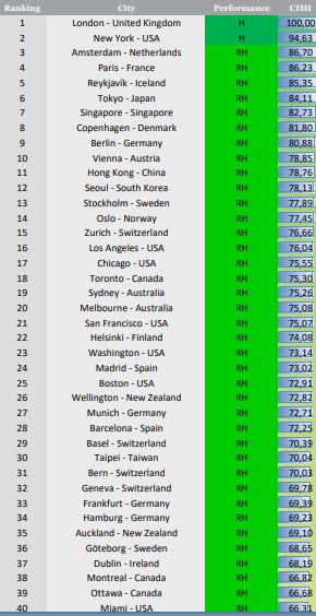
As Per the 2019 Cities in Motion Index (CIMI), introduced by IESE Business School, London and New York are the world’s top two smart cities. The index ranks 174 cities on 9 parameters: economy, governance, urban planning, mobility and transportation, human capital, social cohesion, environment, international outreach, and technology.
Most of the leading smart cities in the world are separated by thousands of miles and different time zones, ethos, culture and their own peculiar spirit and challenges. However, among all these differences, there is one commonality between these cities: use of location intelligence for optimizing performance and agility, streamlining operations, enhancing situational awareness and delivering benefits to the city dwellers.
Six of the CIMI parameters for measuring smart cities benefit from the use of location intelligence:
Environment: Just like in San Francisco, which is 21st in the index, urban planners can design models of potential buildings and predict their environmental impact. From an eco-friendly perspective, they can identify the location for green spaces or plan conservation projects within the precincts of the city. Most polluted areas in a city can also be identified and monitored.
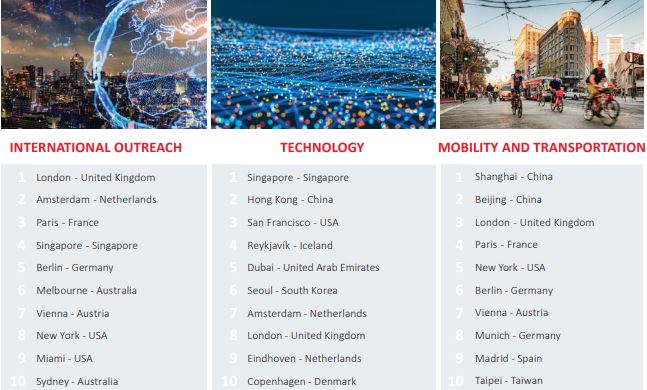
Governance: Democratization of information along decentralization not only makes decision-making faster but also increases citizen participation. City authorities can use Geographic Information System (GIS) for sharing data widely across all departments. Los Angeles, which is at number 16 in the Index, has created a centralized information hub that can be easily accessed. City administration there also communicates with children regarding smart city initiatives.
Human Capital: Location technology helps strategists and demographers in profiling a city’s population patterns and gaining specific insights. Location intelligence makes work considerably easier for experts and planners.
Mobility and Transportation: Transportation systems can be efficiently managed using Location intelligence. For Instance, Metropolitan Transit Authority executives in New York City (number2 on the CIMI) used GIS for managing assets worth $1 trillion and long-term planning for improvements in the subway system. Also, Paris (number 4 in the index) uses IoT applications for optimizing and managing traffic congestion.
London, at the topmost position in the CIMI, combines GIS and BIM for Crossrail, which is Europe’s largest construction project. Executives in Crossrail extensively use location intelligence for knowing the precise details of underground infrastructure to build new tunnels.
Technology: Technology is the cornerstone of smart city development, and location is a key enabler and facilitator of many other technologies. Emerging technologies like AI, ML, DL and IoT will deliver optimum outcome and help in developing new frameworks only when they work in sync with location
Location Intelligence also provides users and organizations with a robust framework for analyzing and managing geospatial data.
Drones, autonomous vehicles, IoT, indoor positioning, digital twins, all collect or rely on location information. The mainstreaming of 5G would be another game changer for location data and foster rapid innovations. This would enable not only an increase in location awareness but also location becoming a pillar of most technological processes. A telecom company in Italy is working to reduce disparity in technology access, while companies US and other places are using AI to power 5G networks that will support smart city infrastructure.
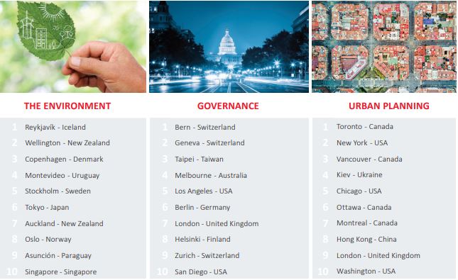
Urban Planning: These days GIS is an indispensable part of any city planning. With the help of GIS and location intelligence, architecture, engineering, and construction (AEC) professionals can see beforehand how a building will look like, or what its structure would be like.
Boston( number 25 in the list) is developing 3D models of its physical infrastructure and using location for better planning and visualization.